
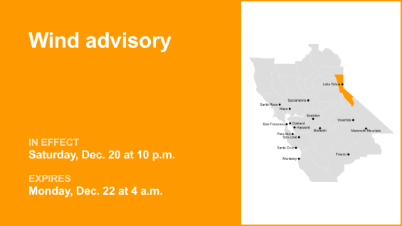
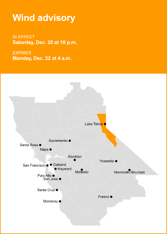
A wind advisory was issued by the National Weather Service on Saturday at 1:39 p.m. valid from 10 p.m. until Monday Dec. 22, at 4 a.m. for the Greater Lake Tahoe Area.
The NWS Reno NV says to expect, “Southwest winds 30 to 40 mph with gusts up to 55 mph. For Lake Tahoe, gusts up to 50 mph with wave heights of 2 to 5 feet. Ridgetop gusts up to 100 mph.”
“Gusty winds will blow around unsecured objects. Tree limbs could be blown down and a few power outages may result. Small boats, kayaks and paddle boards will be prone to capsizing and should remain off lake waters until conditions improve,” the NWS said. “Now is the time to secure loose outdoor items such as patio furniture, holiday decorations, and trash cans before winds increase which could blow these items away. The best thing to do is prepare ahead of time by making sure you have extra food and water on hand, flashlights with spare batteries and/or candles in the event of a power outage.”

Understanding high wind alerts
When it comes to high wind alerts, understanding the levels of risk is crucial. The NWS classifies them into three distinct categories:
High wind warning: Take action!
Sustained, strong winds with even stronger gusts are happening. Seek shelter. If you are driving, keep both hands on the wheel and slow down.
Wind advisory: Take action!
Strong winds are occurring but are not so strong as to warrant a High wind warning. Objects that are outdoors should be secured and caution should be taken if driving.
High wind watch: Be prepared!
Sustained, strong winds are possible. Secure loose outdoor items and adjust plans as necessary so you’re not caught outside.
How to prepare before strong winds approach
- Trim tree branches away from your house and power lines.
- Secure loose gutters and shutters.
- Identify an interior room of your house, such as a basement or interior bathroom, that you can take shelter in during high wind warnings.
- If you live in a mobile home, identify a sturdy building you can go to if the NWS issues a high wind or severe thunderstorm warning.
- Charge batteries of all essential items such as cell phones and booster packs, weather radios and power tools such as a reciprocating saw, which you might need to clear debris.
- Update your emergency kit and be sure to include enough food and water to last for 3 days for each person in your home.
- Make a list of items outside your home you will need to tie down or put away so that they don’t blow away or fly through a window. When the NWS issues a high wind watch, immediately secure these items to avoid damage or injury once the wind starts picking up.
How to act during strong winds
Take shelter:
- Immediately go inside a sturdy building during a high wind warning or severe thunderstorm warning and move to an interior room or basement.
- If you are in a mobile home, move to a sturdy building before the winds pick up or the storm system reaches your location.
If caught outside or driving:
- Take shelter in your car if you are not near a sturdy building. If possible, drive to a nearby sturdy building. Otherwise, move your car to a location where it is less likely to be hit by falling trees or power lines.
- If no shelter is available avoid trees, power lines, and the side of the road. Keep in mind that power lines that are laying on the ground may be live. Do not go near them! Try to find a place that will block blowing or falling debris.
- If you are driving and aren’t near a sturdy building, hold the steering wheel with both hands and slow down.
- Keep a distance from high profile vehicles such as trucks, buses and vehicles towing trailers. One strong gust of wind can be enough to flip one of these trailers onto its side.
What to do after strong winds subside
- Do not go near downed power lines. Report downed power lines to the police.
- Be careful when handling debris that may have blown into your yard.
For more weather alerts in the Tahoe area, visit Weather Advisories